
February 2016. Guatemala City was covered by a dense fog when César picked me up at my hotel at 5:30 AM. I’d already filled my travel mug with hot coffee, brain fuel for at least part of our drive to the Sierra de las Minas. Traffic was jammed at that hour, but after about 45 minutes we were out of the city, the highway plunging eastward into the upper reaches of the Motagua Valley. It is a spectacular landscape here. As it got light we could see that the valley was filled with a thick smoke haze from the dry-season burning of agricultural fields. We reached Teculután, a busy farming town, at about 10 AM, and met Danilo and Edwin at “Cindy’s Hotel y Restaurante,” as we had arranged. Over a hearty breakfast of huevos rancheros, Danilo gave us a briefing on the work his non-profit organization, Defensores de la Naturaleza, had been doing to establish a fondo de agua, a water fund, on the southern slopes of the Sierra de las Minas mountain range.
I was here as team leader for an assessment of the state of conservation of forests and biological diversity in Guatemala, being conducted for the U.S. Agency for International Development, USAID. A provision in the U.S. Foreign Assistance Act, which governs USAID’s international development activities, requires that this type of assessment be done whenever a USAID mission in a country is developing a new strategy for their development aid. USAID-Guatemala was in the process of doing so, and we were here to help them incorporate ecological issues into their planning. My two Guatemalan team members, César and María, are both scientists at IARNA, the Instituto de Agricultura, Recursos Naturales y Ambiente, a sort of think-tank and consulting shop associated with the Universidad Rafael Landívar, a private Jesuit university in Guatemala City.
In our meetings and interviews with government officials, non-governmental organizations, communities, and academic scientists over the previous few weeks we had heard over and over about water problems and issues. Several of our key informants proposed that water was a theme that integrated the protection of forests and biodiversity with societal needs, because water depends on ecohydrological processes in watershed ecosystems, and water is an irreplaceable resource for human health and sanitation, agricultural production, and economic development. We’d heard about water so much that we were leaning toward recommending that USAID’s strategy should emphasize water as an integrating ecosystem service, and that its programs should integrate biodiversity conservation, economic development, and climate resilience at a watershed scale.
It was during those meetings that we learned about the water fund being developed in the Sierra de las Minas Biosphere Reserve by Defensores de la Naturaleza, a Guatemalan conservation organization, and the World Wildlife Fund’s (WWF) Guatemala Program. Oscar Nuñez, the Executive Director of Defensores, had invited us to take a field trip to the Sierra de las Minas to meet some of his field staff and see the area where the water fund was being implemented, and we were happy to take him up on the offer.
——-
The Motagua Valley is underlain by a major fault zone that marks an ancient plate-tectonic boundary between the North American Plate and the Caribbean Plate. It is a depression or trough created by tectonic forces, a “graben” in geological terms, through which the Río Motagua flows; the river didn’t carve the valley. To the north the Sierra de las Minas form a mountain wall up to 3,000 meters, or almost 10,000 feet, high, which cuts off the flow of moist Caribbean air from the northeast and creates a steep and dramatic “rain shadow” effect. The Motagua Valley is one of the driest places in Central America, but is only around 30 kilometers from one of the wettest places, on the northern slopes of the mountain range. Although it is a relatively small country, Guatemala’s topographic and climatic diversity has created a high level of biological diversity in both its ecosystems and species, and there was no better place to see that than here.
The name of the range, minas, refers to mines in Spanish. These are the Mountains of the Mines. The same tectonic forces that pushed up the mountains and depressed the valley also created the intense heat and pressure that metamorphosed limestone into marble, and serpentine into jade. Pre-Columbian mines on the southern flanks of the mountains were a major source of Mayan jade, which was traded throughout Mesoamerica. The pure white marble – mármol in Spanish – that we saw in a quarry we passed is the result of metamorphism of a very pure limestone. Gold and other precious metals are also found in these mountains.
Sierra de las Minas became a Biosphere Reserve under the UNESCO Man and the Biosphere Program in 1990. It is co-managed through an agreement between the Guatemalan National Council for Protected Areas – CONAP by its acronym in Spanish – and Defensores de la Naturaleza.
After breakfast, Edwin Sosa, a forest management specialist working for Defensores, climbed into our vehicle to guide us up into the sierra for the day. I was excited to get a firsthand look at the changes in vegetation going up into the mountains, and to better understand how those ecological changes influenced watersheds and water flows – the “ecohydrology” of the Sierra de las Minas. With that understanding we would be in a better position to make strategic recommendations in our tropical forests and biodiversity assessment.
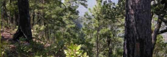
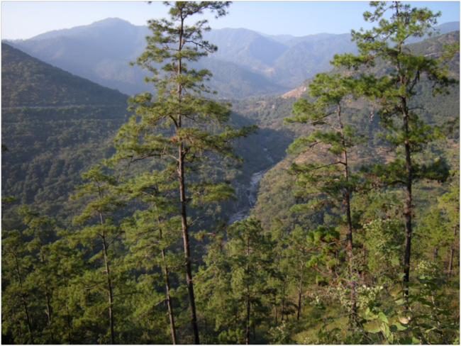
View of vegetation on the lower south-facing slopes of the Sierra de las Minas
The concept of vegetation zones – of ecosystems being associated with elevation and climate – is an old one. It was first described by the great German explorer and geographer Alexander von Humboldt in his 1805 book Essay on the Geography of Plants. He and his travelling companions almost managed to climb Chimborazo, a volcano in Ecuador, in 1801, reaching an altitude of almost 20,000 feet, only about 1,000 feet below the summit. In the Geography of Plants, Humboldt illustrated the distribution of vegetation on Chimborazo in altitudinal zones in a figure that is now recognized as one of the earliest and most creative pieces of scientific art and communication ever produced.
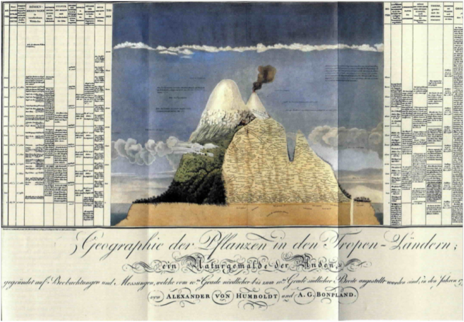
Illustration of the vegetation zones of Chimborazo, Ecuador. Alexander von Humboldt, 1805.
In 1889 the pioneering American ecologist C. Hart Merriam applied Humboldt’s ideas in his study of vegetation in the San Francisco Peaks near Flagstaff, Arizona, and surrounding areas. Merriam described six “life zones,” based on the changes in temperature and precipitation associated with elevation, from the bottom of the Grand Canyon to the summit of the mountains. He recognized that these altitudinal vegetation zones paralleled ecological changes associated with latitude, and gave them names that corresponded to geographical regions in North America, from Lower Sonoran, through Canadian and Hudsonian, to Arctic-Alpine.
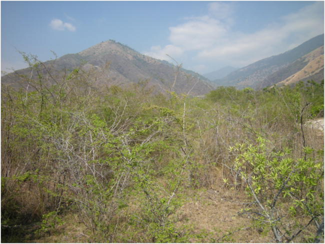
Thorn scrub (monte espinoso) in the lower watershed of the Río Teculután, Motagua Valley
As we switchbacked up the south-facing slopes of the Sierra de las Minas above the Motagua Valley we were seeing a textbook example of the “life zones” concept of Humboldt and Merriam. Teculután, where we ate breakfast, is at about 250 meters above sea level, There, in the bottom of the valley and in the rainshadow of the mountains, it is very dry. The vegetation is thorn scrub, called monte espinoso here. There are lots of species of leguminous trees and shrubs with spines and tiny leaves, and many of these shed their leaves in the dry season – which was now. The look of the vegetation was thin and grey. In structure and appearance it was very similar to the thorn scrub of East Africa I’m familiar with.
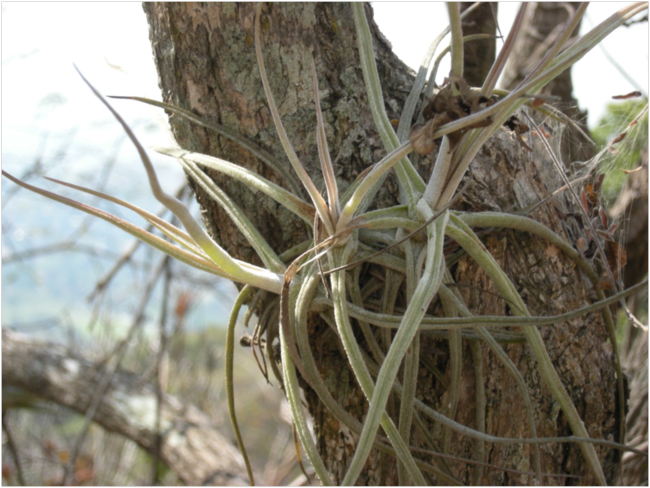
A species of Tillandsia, a bromeliad “airplant,” found in thorn scrub and dry forest vegetation zones
We headed up the slope on a contouring gravel road, passing through the next vegetation zone, bosque seco, or dry forest. The trees in this zone were mainly broadleaved, but dry-season deciduous, and nearly leafless now, reminding me of African miombo woodland in the dry season. At an elevation of about 600 meters we entered the oak zone, with several species of Quercus, some of which still had leaves. By 900 meters in elevation some pines started to mix with the oaks, and by 1,100 meters it was mostly pine. We eventually went up to almost 2,000 meters, still surrounded by beautiful pine forest.
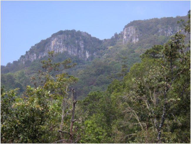
Looking up at the marble cliffs of the Sierra de las Minas in the pine-oak zone
The main pine here is Pinus oocarpa, which has a number of fire-adapted traits that to me seemed to fall somewhere between those of ponderosa pine (Pinus ponderosa) and lodgepole pine (P. contorta) in my familiar Colorado or New Mexico woods. The bark on old Pinus oocarpa trees is very thick at the base, insulating the tree from ground fires. The growth form is tall and with self-pruning lower branches, which helps to keep those fires from reaching up into the canopy. Pinus oocarpa has some serotinous cones, which only open to release seeds after being heated by a fire, although it didn’t look like they were 100% serotinous here. The young trees spring up six, eight, or even ten feet before producing a little umbrella of branches and needles, an adaptation to get quickly above the reach of ground fires. Burned stumps sprout new growth after fires, another adaptation to frequent fire. We saw several big, old living trees with fire scars that recorded past fires they had experienced and survived.

Old fire scar on Pinus oocarpa
Edwin had recently been to a three-week fire management training course in New Mexico, sponsored by the U.S. Forest Service International Programs Office. The course had been held in the Valles Caldera National Preserve in the Jemez Mountains, near where I grew up in Los Alamos. He was very aware of the need for careful fire management here in the Sierra de las Minas. If fires are suppressed in fire-adapted pine forests like these, or those in New Mexico, they can easily become too dense and very fire-prone, risking unnaturally extensive and destructive fires. We saw some areas that were tending in that direction. Edwin said that Defensores has so far been focused mainly on fire-suppression activities, but they have started to experiment with prescribed, controlled burning also, knowing that they need to restore fire into this ecosystem to prevent unnaturally severe and destructive fires later.
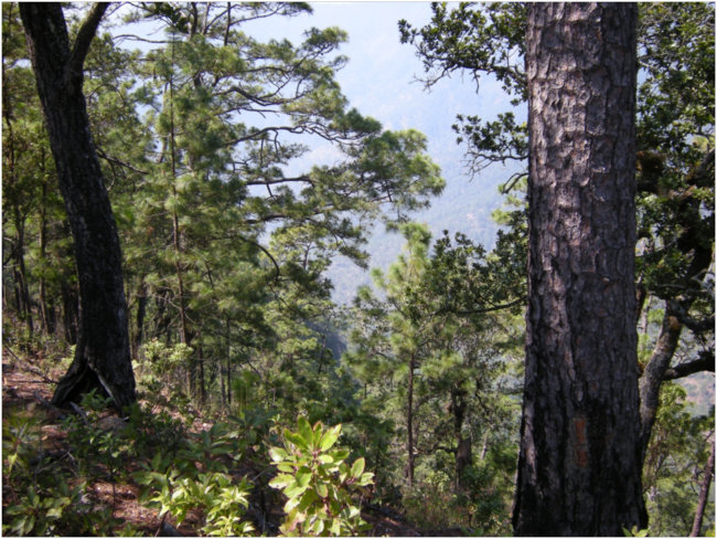
Dense pine (Pinus oocarpa) forest on steep slopes of the watershed of the Río Pasabién. Tree on the left has an old fire scar at its base.
The road was generally very bad – hellish 4WD driving, in fact – and César was struggling beyond his experience. A couple of times Edwin coached him to drive on the high places rather than in the ruts, and to shift down and use the engine as a brake going down steep grades instead of riding the brakes. But what made me really nervous was that sometimes the downhill sides of clockwise, right-bending curves were deeply undercut by water, creating a vertical drop of ten or fifteen feet, or sometimes more. César didn’t seem to be paying attention, and cut many of these turns way too close, with the rear passenger-side wheel only inches from the drop. As I watched this from the passenger seat, I could picture us dropping off and rolling down into the thick forest, never to be heard from again. Finally Edwin caught on, and gave César some stern coaching on how to hug the driver’s-side bank on these turns. These roads appeared overgrown and seldom used – they were probably only used occasionally by Defensores and their fire-fighting teams. Although we were still in the area considered the zona de uso multiple, or multiple use zone, of the Biosphere Reserve, there are no communities living up this high.
It was way up in here, on the north-facing sides of some cool, moist canyons, that I first noticed the red “fall” leaves of a Liquidambar styraciflua, sweet gum. Sweet gum is common in the woods near where I live in northern Virginia, and I’d seen it before in Central America, in the lower fringes of cloud forest in La Tigra National Park in Honduras. Then we passed a tree with maple-shaped leaves, as red and orange as a New England fall. Edwin said they were “mah-ples,” pronouncing the word “maples” as a Spanish-speaker would. The leaves looked a lot like sugar maple leaves, but I really couldn’t believe they were. I took pictures, and collected one beautiful leaf to press, promising Edwin I’d try to find out which maple species this was.
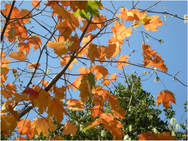
Maple in a cool, moist canyon, Sierra de las Minas
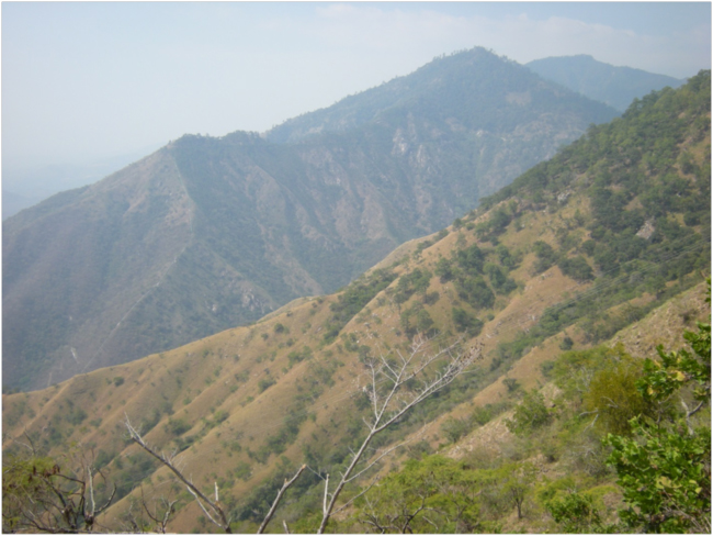
We finally got to the highest point to which Edwin wanted to take us, at 1,900 meters on a ridge where we could look into the steep canyon of the Río Pasabién, and down on a little community called Santa Rosalia Mármol, situated along the river. Above us, going up to the highest peaks at around 3,000 meters, or almost 10,000 feet in elevation, were montane humid broadleaf forests and cloud forests. The roads were too bad and the day too short for us to go farther up in a one-day trip. According to Oscar Nuñez, the Sierra de las Minas has about 70,000 hectares of cloud forest, the largest area of this type of vegetation in all of Central America. It is the “water factory” for all of southeastern Guatemala, he said.

Edwin and César looking out over the watershed of the Río Pasabién
Then we drove down, down, down, and down the terrible road, in some places pure rock and gullies, finally reaching Santa Rosalia two hours later. Along the road through the village, ditches diverted water from the river to irrigate bananas and papayas. Laundry hung on fences in the sunny late afternoon. The few people we saw sat under shady eaves or rested in hammocks. At the bottom of the village some kids were bathing and swimming in the embalse, a reservoir behind a shallow dam, which was the intake for the hydroelectric plant operated by Hidroeléctrica Pasabién. The water of the river is diverted into a canal that snakes at contour along the side of the valley above the river, which itself drops down a steep gorge below Santa Rosalia. The canal then feeds into a tunnel a kilometer long, and on the other end the water goes into a big green pipe a meter wide, which then plunges down the steep slope into the Motagua Valley, and at the bottom a turbine churns out electricity. During the rainy season it can produce 12 MW of power, Edwin said, but now, in the dry season, it can be as little as 2 MW. The village of Santa Rosalia doesn’t even have a piped water system, but the hydroelectric company pays nothing for the water they get from the Río Pasabién.
Río Pasabién below Santa Rosalia Mármol, Sierra de las Minas Biosphere Reserve
From Santa Rosalia down, the road became much better, and in another hour we were passing through huge melon fields on the valley floor. This is a big area for growing export crops like watermelons and cantaloupes, irrigated with water from the mountains. Danilo was waiting for us at Cindy’s Restaurant – making sure we hadn’t rolled into a gully, I guess. After gulping down cold Coca Colas, we headed toward Guatemala City, and were back in town by 8 PM.
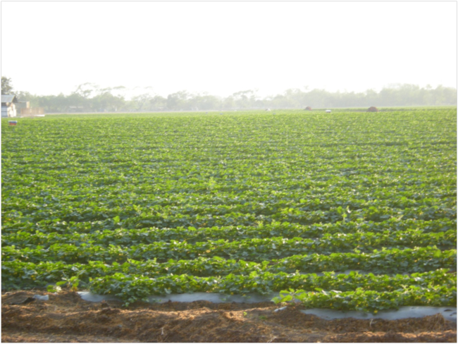
Irrigated melon fields near Teculután
——-
The next morning at my hotel I googled for information on maples that could be found in Central America, and was surprised to learn that sugar maples live as far south as the Sierra de las Minas! My suspicion was correct. The scattered populations of sugar maples found in the mountains of Mexico and Guatemala, documented in a Master’s Degree study by Yalma Vargas-Rodríguez, are relict populations. They are now isolated in high-elevation refugia to which they retreated as the climate warmed after an earlier glacial period when continuous cool forests like those of New England must have reached all the way to Central America. Vargas-Rodríguez hypothesized that the cloud forests of Mexico and Guatemala where the sugar maple is found “contain a unique and ancient flora, were connected and shared species before the Pleistocene, and currently function as tree refuges of that ancient flora.”
The subspecies of the sugar maple found here, Acer saccharum skutchii, the cloud forest sugar maple, is named after the scarcely-remembered American naturalist, Alexander F. Skutch (1904-2004). I mentioned Skutch in my earlier story about seeing a quetzal on the slopes of Volcán Atitlán, because he was the first to describe the life history of that elusive bird. He was born in Baltimore, Maryland, earned a Ph.D. in botany from Johns Hopkins University, got a job with the United Fruit Company in Central America, fell in love with tropical nature, and studied it to the end of his life.
Guatemala is part of the Central American land bridge, where flora and fauna from North America, the Nearctic biogeographical realm, and South America, the Neotropics, come together. David Rains Wallace called it “the monkey’s bridge” in his 1997 book with that title. It is a place where many species of plants and animals are at the edges of their biogeographic ranges. The cloud forest sugar maple, Acer saccharum skutchii, is one example, found here at 15º N latitude – a subspecies of the North American sugar maple that can be found to about 50º N latitude in southeastern Canada.
Genetic diversity is present in every species, and it allows a species to tolerate a range of environments and to adapt and evolve in response to environmental changes over evolutionary time. Populations of Acer saccharum skutchii in the Sierra de las Minas undoubtedly contain unique genes and genotypes that have been selected for there. Those genes may enable sugar maples to adapt to, and survive in, the new conditions resulting from anthropogenic global warming. Who knows – the maple syrup industry in Vermont may eventually have to import cloud forest sugar maple genes and seeds to help Vermont maples tolerate the coming warmer climate.
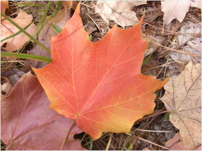
Leaf of cloud forest sugar maple (Acer saccharum skutchii), upper watershed of the Río Teculután, February 2016
——-
Climate models of the Intergovernmental Panel on Climate Change (IPCC) predict a warming and drying climate in Guatemala during this century. The IPCC models predict increased temperatures of around +2° Celsius, and a 10-20 percent decrease in precipitation during the April-September rainy period, by mid-century in eastern Guatemala. These changes in temperature and precipitation would represent a significant shift in the climates found at various elevations throughout the country, which would affect species and ecosystems and shift vegetation zones. For example, areas suitable for cloud forests would decrease with warming and drying at higher elevations. Areas with climates suitable for dry forests would increase, as the climate zones they inhabit expand upward. These predicted changes would affect ecological functioning, and therefore affect the products and services that ecosystems produce.
In our draft assessment report we introduced a topographic perspective on Guatemala’s ecosystems, organizing them into five categories that share similar elevational and climatic features, and which in turn lead to similarities in ecological structure and function. Generally speaking, the ecological processes and functions of these five ecosystem types are linked through the ecohydrological processes taking place in watersheds.
In Guatemala, a “top-of-watersheds” view should guide planning for biodiversity conservation and sustainable human development in an era of climate change. The water-capturing cloud forests and montane humid broadleaf forests at the tops of watersheds, and the belts of pine and pine-oak forests that surround them, deserve a great deal of attention and investment because of the role they play in ecohydrology. Protecting these ecosystems that provide the ecohydrological services in watersheds is especially critical, given the likelihood that water supplies will be an increasing challenge in a warming and drying climate. Using a watershed perspective in planning and management automatically creates a platform for integrating ecological and social systems.
A Coca Cola bottling plant in Río Hondo, a bottled drinking water company, Agua Pura Salvavidas, Ambev, another beverage company, and ENEL, a hydroelectric company in San Geronimo are contributors to the Fondo de Agua. The water fund aims to use money collected from these water users to protect water recharge areas in upstream watersheds and improve forest management there. So far the amounts contributed are small – around $25,000 U.S. dollars each – and the areas targeted are modest – only hundreds of hectares out of hundreds of thousands in the Biosphere Reserve. The need for scaling up is clear. Hidroeléctrica Pasabién, the hydroelectric company whose system we’d seen, has so far refused to join the water fund. Guatemalan water law doesn’t provide any real incentives for them to do so.
In a meeting with staff from WWF-Guatemala, we learned about a study that used stable isotopes of hydrogen (deuterium) and oxygen (O-18) to trace water flows in the Sierra de las Minas from where the water first went into ground to where it came out in the lower watersheds of rivers entering the Motagua Valley. The study was able to map “critical areas” for water recharge of the Río Pasabién watershed. Guess what? The critical areas for water recharge are in the cloud forests of the upper watersheds – home of the cloud forest sugar maple. The drinking water and Coca Cola bottlers, the hydroelectricity companies, the melon growers, and the communities of the Motagua Valley depend daily on ecohydrological services of those fog- and rain-drinking forests – the drip, drip, drips from the leaf tips of Acer saccharum skutchii.
——-
When I first heard yesterday that the name of the little village below us on the Río Pasabién was Santa Rosalia, I thought immediately of an old article that I first read in graduate school, “Homage to Santa Rosalia, or Why Are There So Many Kinds of Animals,” written by C. Evelyn Hutchinson, a well-known ecologist from Yale. He proposed that Santa Rosalia, a 12th century Italian saint, should be considered the patron saint of biodiversity and evolutionary studies. It would be appropriate, I thought, that the quiet village we’d passed through yesterday afternoon is named for the patron saint of biodiversity. The Río Pasabién and the other 62 rivers flowing out of the Sierra de las Minas get their water from the slow drip of rain and fog from the leaves of Acer saccharum skutchii and other cloud forest species, themselves a testament to the creativity and resilience of evolution in responding to environmental change over a long, long time. Will we be wise enough to recognize and conserve that patrimony of nature?
For related stories see:
- Coffee and Quetzal at Los Tarrales, Guatemala. March 2016.
- My Beer Comes from the Mountains: Watersheds, Wilderness, and Indian Peaks Pale Ale. July 2015.
- The View from Zomba Mountain: Plants, Water, and People in Southern Malawi. June 2015.
- Forest of Hope: A Visit to Gishwati Forest. September 2014.
- Ecohydrology of the Honduran Highlands. September 2013.
- A Sunday Afternoon on Cerro Guanacaure, Honduras. August 2013.
Sources and related links:
- IARNA: Instituto de Agricultura, Recursos Naturales y Ambiente
- Defensores de la Naturaleza
- The Monkey’s Bridge: Mysteries of Evolution in Central America. David Rains Wallace. 1997. Sierra Club Books.
- Vargas-Rodríguez, Yalma L. 2010. Una población relicta de Acer saccharum skutchii (Aceroideae) en el estado de Guerrero, México. Act. Bot. Mex no.95 Pátzcuaro abr. 2011.
- Vargas-Rodríguez, 2005. Ecology of Disjunct Cloud Forest Sugar Maple Populations (Acer Saccharum Skutchii) in North And Central America.
- Guatemala Tropical Forests and Biodiversity Assessment Draft Report March 2016
- Partnering to Protect a Vital Water Source in Guatemala. The WWF and Defensores Water Fund in the Sierra de las Minas.
- E. Hutchinson. 1959. Homage to Santa Rosalia or Why Are There So Many Kinds of Animals?


