
January 2016. The Department of Petén covers the northern third of Guatemala. It is a vast region of lowland forests, rivers and lakes, home to only around four percent of Guatemala’s population of 15 million. It’s a long way from Guatemala City and the south, where most of the population lives. Ruins of Mayan cities dot this landscape, including Tikal, perhaps the most famous of them. I visited Tikal in 2014, and wrote a story about that visit called “Ecological Musings in the Maya Forest.” Here are some more musings.
I’ve posted two previous stories from my work in Guatemala at the beginning of this year. As I explained, I was team leader for an assessment of the state of conservation of forests and biological diversity in Guatemala, being conducted for the U.S. Agency for International Development, USAID. A provision in the U.S. Foreign Assistance Act, which governs USAID’s international development activities, requires that this type of assessment be done whenever a USAID mission in a country is developing a new strategy for their development aid. USAID-Guatemala was in the process of doing so. Working with two Guatemalan team members, our aim was to give USAID ideas about how they could incorporate ecological issues into their development strategy.
USAID has been supporting forest and biodiversity conservation activities in Petén for decades, and it seems likely they will continue to do so, and so we needed to visit the region as part of our assessment process. Our base for gathering information about the conservation challenges and needs in Petén was Flores, the capital of Petén Department. Flores sits on an island in Lake Petén Itzá, connected by a long causeway to the mainland and its sister town of Santa Elena. It has a laid back, run down charm, and a kind of Mediterranean feel, with narrow streets and pastel-colored buildings. It’s the base for day trips to Tikal and other Mayan sites, so sometimes the streets are a mayhem of tourists and buses. In Flores and Santa Elena we met with various government agencies and non-governmental organizations working on forest and biodiversity issues in the region, and launched out on several day trips in different directions to see some of the challenges on the ground.
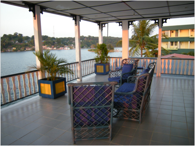
View from the Hotel Casazul, Flores
The northern tier of Petén, bordering Belize and Mexico, is designated as the Maya Biosphere Reserve, which was established under the UNESCO Man and the Biosphere Program in 1990 to protect the largest area of tropical forest remaining in Central America. With an area of around 22,000 square kilometers, it is more than twice as large as Yellowstone National Park, which has an area of about 9,000 square kilometers. The comparison with Yellowstone is not fair, however. Only about 7,700 square kilometers, or 36% of the Maya Biosphere Reserve, is a core zone, consisting of national parks and nature reserves, in which – supposedly – no human settlement, logging, or extraction of resources are allowed. In the buffer zone and multiple use zone, settlements and economic activities are allowed – supposedly regulated and supposedly compatible with the sustainable conservation of the reserve. According to the latest report from the Maya Biosphere Reserve monitoring program, in 2014 there were 56 communities within the reserve, some within the supposedly off-limits core zone, with a total population of around 40,000 people.
Our first trip out of Flores was to the north, into the Maya Biosphere Reserve and to Laguna de Tigre National Park. After an early breakfast at Café Doña Gaya, where we watched the sun come up on the calm morning lake, and small boats, like water taxis, taking people to work on the mainland or bringing them to the island, we went to the local CONAP office to pick up the park director. CONAP is the Consejo Nacional de Areas Protegidas, or National Council for Protected Areas, responsible for managing the biosphere reserves, national parks, and other protected areas of Guatemala. An emergency had come up, and the director wasn’t able to go with us, but he sent Célica Contreras, the community conservation coordinator, as our guide on the trip to the park and our visit to the community of Paso Caballos.
Paso Caballos is the name of an old chiclero camp at the head of the Río San Pedro. Chicleros were the harvesters of chicle, the sap of Manilkara chicle and several other tree species in the same genus, from which chewing gum used to be made before a synthetic substitute was developed that killed the wild-harvesting industry. Chicle harvesting used to be a significant part of the economy here in these lowland forests of Petén. The Paso Caballos community is one of four native communities with acuerdos de intención – agreements of occupancy and management – that are allowed to legally occupy land within the Parque Nacional Laguna de Tigre.
We drove west from Flores around the end of Lake Petén Itzá, then north-northwest to the park. We were already in the Maya Biosphere Reserve, but in the zona de amortiguamiento, or “buffer zone,” which is about 35 kilometers wide. The landscape here was mainly large-scale cattle ranches, the native forest having been cleared for pasture where now herds of humped, dewlapped, floppy-eared zebu cattle grazed on rich tall grass. After about an hour and a half of driving on a potholed and rock-strewn gravel road, we came to the control post gate, and entered Laguna de Tigre National Park. It was another fifteen minutes to Paso Caballos.
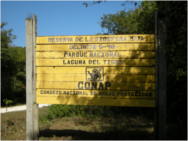
Entrance gate sign at Laguna de Tigre National Park
The local comité comunitario de desarrollo, the community development committee – a dozen local men, and only men – was waiting for us in a big, open-sided barn-like structure thatched with palm leaves that serves as the town hall and community center of Paso Caballos. We sat in a circle of benches and chairs and talked. This was a Kekchi Mayan community, and the language shifted back and forth from Spanish to the strange and gentle rhythms of Kekchi, as the committee members discussed finer points among themselves, and then their several leaders translated the group sentiment to Spanish for us outsiders. Some of the leaders looked to me to be between 35 and 45 years old; one said he had lived here 15 years, another 18 years. They all seemed friendly, but at the same time a bit wary.
The leaders and spokesmen seemed like natural leaders, trusted by their fellows and not afraid to speak. A couple of them mentioned that they just wanted to live una vida tranquila, a quiet life – to grow their crops, and raise their families in the midst of the beautiful forest. They stated said they did not want to do anything illegal that would get them in trouble with the authorities, who might hassle them and ruin their quiet lives. I liked these simple, calm men.
Near the end of our meeting one of the men mentioned that one of the rules of the agreement that allows them to live here within a national park is that each family is supposed to maintain 20% of their family parcel in natural forest, as a reserva forestal, a “forest reserve.” I thought it would be really interesting to see how that was working, so I suggested that we go see a family forest reserve, assuming it would be a only few minutes’ walk away. After quite a bit of discussion in Kekchi, the estimate came back that it would be a three kilometer walk to the closest one. We were feeling a bit pressed for time, and decided not to go.
——-
The time pressure was because we also wanted to go down the Río San Pedro to the Estación Biológica de las Guacamayas, a research station and ecotourism facility. “Scarlet Macaw Biological Station” would be the English translation. A species of significant focus here is the scarlet macaw (Ara macao), or guacamaya in Spanish. This beautiful large parrot is the victim of illegal capture and international trade, and the Maya Biosphere Reserve has a significant population. Because of their large range in the Neotropics, scarlet macaws are not considered to be a threatened or endangered species according to the International Union for the Conservation of Nature, IUCN, but they are of concern to conservationists wherever they are found. The illegal pet trade is the main threat to many populations, combined with habitat loss, and the species is listed on Appendix I of the Convention on International Trade in Endangered Species (CITES), which bans all international trade. I’d seen scarlet macaws on a previous trip to Belize, along the Río Macal. They are spectacular.
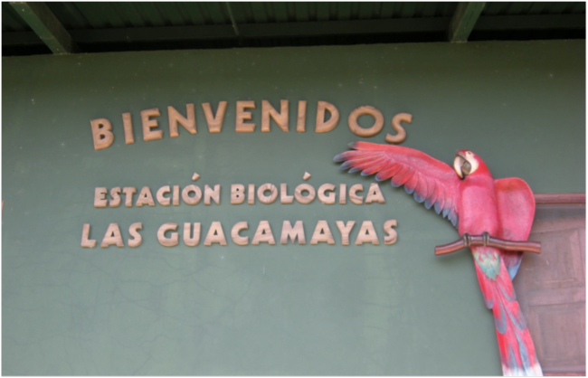
Welcome sign at the Estación Biológica las Guacamayas
The Río San Pedro emerges from underground as a spring of clear water at Paso Caballos. Just below this beautiful spring we climbed into an aluminum skiff owned by the Wildlife Conservation Society’s (WCS) project here in the Maya Biosphere Reserve, and headed downriver in the hot sun of early afternoon. We made a sharp left turn not far downstream at the first tributary entering the Río San Pedro from the south, and took a side excursion upriver to see where a giant diesel pump was sucking water from the river and sending it a few kilometers away, to sprinklers that irrigated a new oil palm plantation. According to everyone we talked to this was an illegal plantation, in violation of the regulations about what could take place in the Biosphere Reserve. They claimed that the Spanish owners were thumbing their noses at Guatemalan law, but also that the Guatemalan Government wasn’t enforcing the law and shutting down the oil palm plantation. Many people said they thought that there was money changing hands under the table, that corruption was the cause of this new plantation on the border of the national park. The expansion of oil palm plantations, driven by global demand for palm oil, is a major emerging threat to these Petén forests.
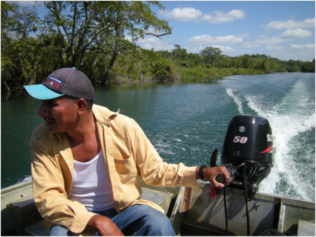
Running down the river
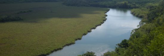
A few kilometers downriver we pulled up on the north bank, and climbed a short trail to the Biological Station. It was a hot, quiet afternoon. An international birding tour had left the day before and the birding guides were relaxing; the WCS biodiversity monitoring staff were compiling their data; an American volunteer was eager to speak some English with me. We walked up a steep shady trail through the forest above the station to an observation tower on the bluff above the river, with an expansive view up and down the Río San Pedro, which here is the southern boundary of the Parque Nacional Laguna de Tigre. We could see the sprinklers at the new oil palm plantation off to the south. We didn’t expect to see guacamayas on this hot afternoon, and didn’t see any.
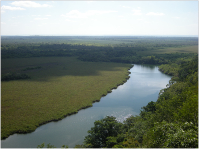
View westward down the Río San Pedro from the observation tower at the Biological Station
——-
After returning to Paso Caballos from our visit to the Estación Biológica, we drove south toward Flores on the potholed road. I had plenty of time to review my notes and ponder what we had seen today. The Paso Caballos community was established in 1997 with 112 families, one of the community leaders told us, and now they are 290 families and around 2,000 people. I quickly did the “back of the envelope” calculations in my notebook. That would mean more than a doubling of the population in 19 years, which works out to a population growth rate of more than 3.5% per year. Family size here is about 7 people, meaning each couple has an average of five children. The Paso Caballos community seemed to me to be a ticking “population bomb,” to use the phrase from the title of Paul Ehrlich’s 1968 book, or a pond heading toward “the twenty-ninth day,” the title of Lester Brown’s 1978 book about the collision between human reproduction and the limits of ecosystems to support them.
And, of course, my ecological musings took me back to the demise of the Classic Maya. Michael Coe, one of the most knowledgeable scholars of the ancient Maya, wrote in Breaking the Maya Code that “Maya civilization, which reached its peak of achievement in the eighth century, must have contained the seeds of its own downfall. When civilizations collapse, there is not one probable cause, but many. Certainly, Maya population densities had passed beyond the ‘carrying capacity’ of the environment: there is abundant evidence for erosion and environmental degradation, greatly increased internecine warfare, and near universal acts of what looks like revolutionary destruction of elite monuments. It has been shown that there was a series of severe droughts in the Maya lowlands at about the same time.” After 900 CE these Classic Maya cities collapsed and “much of this vast area reverted to jungle,” according to Coe. That once heavily farmed and inhabited area is the Maya Biosphere Reserve of today.
A 2012 study titled Classic Period collapse of the Central Maya Lowlands: Insights about human–environment relationships for sustainability (Proceedings of the National Academy of Sciences, 2012), analyzed archaeological data from across the northern Classic Mayan region to better understand the environmental conditions at the time when the area was abandoned. The study concluded that significant reductions in rainfall at that time were correlated with rapid deforestation, as the Mayans cut and burned more and more forest to clear land for agriculture. The study pointed out that they also required massive amounts of wood to fuel the kilns that made the primitive cement used to build their elaborate cities.
In another study by Robert Oglesby and colleagues, Collapse of the Maya: Could deforestation have contributed? (Journal of Geophysical Research, 2010), population records and measurements from current forested and cleared lands in the Mayan region were used to construct a computer model of deforestation, and these fed into climate model simulations to see how the deforestation would have affected rainfall. They concluded: “Results from simulations with a regional climate model demonstrate that deforestation by the Maya also likely induced warmer, drier, drought-like conditions. It is therefore hypothesized that the drought conditions devastating the Maya resulted from a combination of natural variability and human activities. Neither the natural drought or the human-induced effects alone were sufficient to cause the collapse, but the combination created a situation the Maya could not recover from. These results may have sobering implications for the present and future state of climate and water resources in Mesoamerica as ongoing massive deforestation is again occurring.”
“In a time of unprecedented population density, this combination of factors was likely catastrophic,” wrote Joseph Stromberg in a 2012 Smithsonian Magazine article titled Why Did the Mayan Civilization Collapse? A New Study Points to Deforestation and Climate Change.
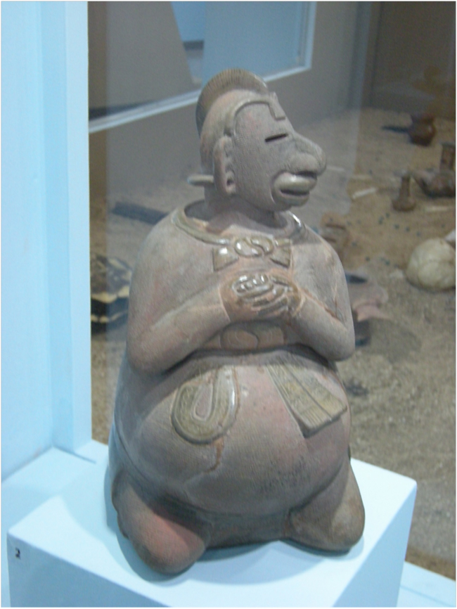
Clay figure representing fertility from Kaminaljuyu, Early Classic Period (200-550 AD), National Museum of Archeology and Ethnography, Guatemala City, Guatemala.
——-
But this population bomb in Paso Caballos, this overgrowing pond, this old-new story of deforestation and climate change in the Maya Forest, should be seen in a broader context. A regional, hemispheric, and global context. The gentle Kekchi farmers we had met briefly in Paso Caballos are only a tiny part of a very complex system.
The conundrum of Paso Caballos, and of the Parque Nacional Laguna de Tigre as a whole, should be seen, according to the Guatemalan experts we interviewed, in the context of narco-ganaderia – cattle ranching by drug lords as a way of laundering drug money. Too many loose dollars from helping to transport cocaine north from Colombia? No problem, just buy some cheap forest land in the buffer zone of the Maya Biosphere Reserve, or better yet just go find a piece of forest in the Laguna de Tigre National Park. Hire some local labor to cut the trees, sell off the mahogany and other high value species, and then burn it to clear it for pasture. Bring in some humped zebu cattle, and dare the authorities to come and stop you. Build an airstrip on your ranch if you want, so planes from Colombia can land and refuel on their way al norte. This is how narco-ganaderia was described to us.
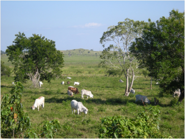
Zebu cattle graze on pasture cleared from lowland tropical forest in the buffer zone of the Maya Biosphere Reserve. January 2016.
The joint monitoring program of CONAP and the Wildlife Conservation Society has been trying to monitor activities of all kinds, including illegal activities, in the Maya Biosphere Reserve. According to the most recent monitoring report in 2014, the northern border of the Laguna de Tigre National Park has the highest density of border crossings – almost none regulated – of any place on the Guatemala-Mexico border. So, if you happen to have a narco-ranch in the national park, you can drive the drugs north through this porous border, sin problema.
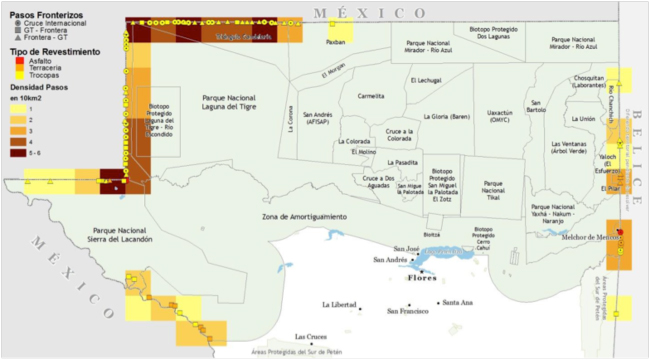
Map of border crossing points between Guatemala and Mexico, showing a concentration in the Laguna de Tigre National Park from 2014 monitoring report by CONAP and WCS
What is needed to protect the environment in the northern Petén is for the Guatemalan government to regain control of this part of the country. In our assessment interviews with a wide range of Guatemalan experts on biodiversity and forest conservation, the third most common theme among the suggestions for needed conservation actions was to stop illegal activities. Here, they suggested, the responsibility lies primarily with the Government of Guatemala. Many of them described Petén as an area largely without the presence of national government institutions, and said that a very strong response was needed to stop illegality. They suggested that the government should use national institutions and power – the army, police, and judicial system – to stop illegal land conversion and other illegal activities in Petén. They said the government needs to control the porosity of the border between Petén and Mexico, using the army and police.
Several people we talked to suggested that until the presence of the state and rule of law are re-established in Petén, investments in forest and biodiversity conservation there would be wasted. Some of them proposed that the U.S. government and USAID could use far stronger diplomatic pressure and aid contingency than they have to stop illegal, drug-related activity in Petén, and suggested that this should be a “national security” issue for the United States.
In the meantime, the quiet farmers of Paso Caballos – and the guacamayas – will keep doing the best they can, trying to keep out of trouble and out of the way of “progress” and globalization. Trying to live una vida tranquila in the Maya Forest.
For related stories see:
- Sugar Maples, Ecohydrology, and Climate Change in the Sierra de las Minas of Guatemala. February 2016.
- Quetzal and Coffee at Los Tarrales, Guatemala. January 2016.
- Ecological Musings in the Maya Forest. March 2014.
- Screeching Macaw, Hidden Jaguar. March 2014.
- Pondering the Ponds of Nags Head Woods. November 2012.
Sources and related links:
- Guatemala Tropical Forests and Biodiversity Assessment Draft Report March 2016
- Maya Biosphere Reserve
- Estación Biológica las Guacamayas
- The Population Bomb. Paul Ehrlich. 1968.
- The Twenty-ninth Day: Accommodating Human Needs and Numbers to the Earth’s Resources. Lester Brown. 1978.
- Michael D. Coe. Breaking the Maya Code. Third Edition, 2012.
- Classic Period collapse of the Central Maya Lowlands: Insights about human–environment relationships for sustainability. B.L. Turner II and J. Sabloff. 2012. Proceedings of the National Academy of Sciences.
- Oglesby, R.J., et al. 2010. Collapse of the Maya: Could deforestation have contributed? Journal of Geophysical Research, V.115.
- Why Did the Mayan Civilization Collapse? A New Study Points to Deforestation and Climate Change. smithsonian.com August 23, 2012
- Monitoreo de la Gobernabilidad en la Reserva de la Biosfera Maya. 2014. CONAP and WCS.


