
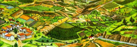
February 2018. I was in Guatemala again, almost exactly two years after my last consulting trip here. As I had done then, I was again travelling east from Guatemala City toward the Motagua Valley, traversing a grand and scenic landscape. Traffic was terrible getting out of the city on that sunny morning, but we thought we had it made when we finally hit normal highway speeds. We should be on time for our 2 PM meeting in Zacapa, with the staff of the regional office of the Instituto Nacional de Bosques, the Guatemalan Forest Service, generally called by its abbreviation INAB. But as the road began to snake and drop into the valley we hit road construction. Traffic slowed to a crawl and then to stop-and-go as the dust from the unpaved stretches of road swirled around us. Later we found out that construction was not the only issue; a big truck had overturned on one of the sharp turns, and the accident compounded the construction delays.
On the positive side, the slowdown gave me a chance to work with Martha María, the coordinator for the U.S. Forest Service International Programs work here, who was driving. During the stop-and-go we finalized a survey to be sent to participants in the training programs that the USFS had been supporting. The survey was one source of information for an evaluation of the USFS Guatemala Program – my reason for being here again. Finally, just before Guastatoya, where the highway crossed the Motagua River on a high bridge, traffic thinned and speeded up. We decided we still had time to stop for a quick lunch at Pollo Campero – I think of it as the Guatemalan version of McDonald’s – a popular and modern fast-food chain. After a chicken sandwich and iced tea, we were on our way again in less than half an hour. In a rush, we passed up the opportunity to stop at the numerous roadside stands offering a beautiful proliferation of local, in-season fruit grown on the irrigated farms of this stretch of the valley: watermelons, cantaloupes, mangos and papayas. We made it to the INAB office in Zacapa right at 2 PM. Things were just getting organized, and we greeted various INAB staff, some of whom we had met and interviewed earlier in Guatemala City.
We finally settled into a conference room to hear some presentations. The regional director gave an interesting talk about how they are now beginning to use an integrated watershed management framework in their forest management work. One slide resonated with me especially, because of my past work in Malawi, Honduras, Kenya, Rwanda and Colorado. It said:
- Si la cuenca es la unidad natural de planificación, se debe considerar la microcuenca como la unidad básica de atención y ejecución de los planes, programas y proyectos de producción agropecuaria e hidrobiológica, recursos naturales y desarrollo social.
- Este enfoque facilita la obtención y aplicación de los recursos humanos, financieros, materiales y tecnológicos, ya que se cuenta con un marco de referencia y de atención concreta a donde implementar los trabajos necesarios en una unidad territorial.
- Alcanzar un uso verdaderamente racional de los recursos naturales, en especial el agua, el bosque y el suelo, considerando al hombre y la comunidad como agente protector o destructor.
Got it? Here it is in English, more or less:
- If the watershed is the natural unit for planning, the micro-watershed should be considered as the basic unit of attention and execution of plans, programs, and projects for agricultural production and ecohydrological services, and for natural resources management and socio-economic development.
- This focus facilitates the acquisition and application of human, financial, material and technological resources, because there is a frame of reference, and specific attention can be given to where to implement the work that is needed in a geographical area.
- This approach can help to achieve a truly rational use of natural resources, especially water, forests, and soils, which views people and communities as both protective and sometimes destructive agents.

Slide depicting integrated watershed management from INAB Region III presentation in Zacapa, February 2018
We also heard presentations from INAB’s head of forest protection, whom we had met before in Guatemala City, and from the fire management coordinator of INAB’s Region III, whose headquarters are in Zacapa and which covers a number of departments in the southeastern part of Guatemala, including the Sierra de las Minas mountains that form the northern wall of the Motagua Valley. All of this was confirming and extending what I had learned on my trip two years ago. In the report from that trip, we recommended that watersheds should be the focus of planning, and that in some ecosystems, such as the pine forests of the Sierra de las Minas, fire ecology and management was a topic of special importance.
——-
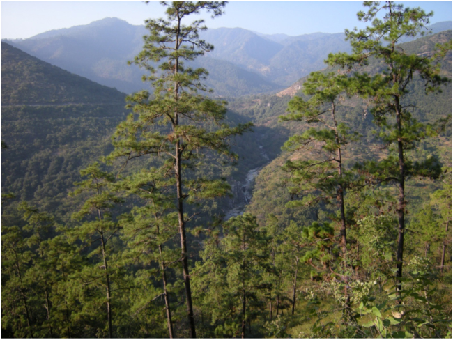
On that trip in 2016 we drove up into the Sierra de las Minas, switchbacking up the steep south side of the range in the watershed of the Río Teculután. We climbed through the dry forest ecosystem into a zone of oaks, then through a transition from oak to pine, and finally into the vegetation zone dominated by Pinus oocarpa. The pines were obviously a fire-adapted species: many older trees had visible scars from past fires, and their characteristics – thick flaky bark and cones that remain closed until opened by heat – confirmed that they had evolved in a fire-prone environment. The road wound through the pine forest, slowly ascending to the edge of the cloud forest zone, where we saw what is truly a biodiversity treasure, the southernmost population of sugar maples on Earth: the cloud forest sugar maple, Acer saccharum skutchii.

Surveying the forests of the Sierra de las Minas, February 2016
Some stands we passed through were crowded with young pines. These areas obviously hadn’t experienced a recent stand-thinning fire and were very susceptible to an intense fire that could jump to the tree crowns and kill all of the trees. In the U.S., unnaturally dense, fire-adapted forests in the west have recently experienced catastrophic wildfires, the result of a policy to suppress all forest fires that was not based on a scientific understanding of the fire ecology of those forests. I was familiar with the effects of some recent fires in the Colorado Front Range, which devastated the downstream ecological services that forests provide in watersheds. Reservoirs for domestic water supplies and hydroelectric power for Denver were filled with silt from erosion of those intensely-burned watersheds in some cases, for example. I doubted those lessons were being translated and applied here in the Pinus oocarpa forests of the Sierra de las Minas.
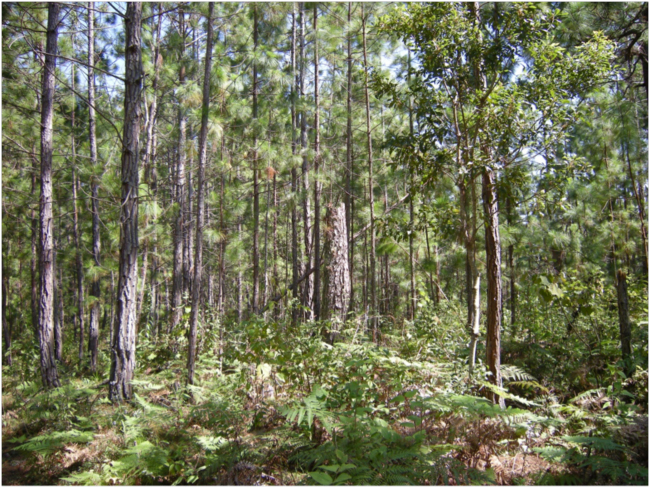
Dense young stand of Pinus oocarpa, Sierra de las Minas, February 2016
At the end of a long day, we again switchbacked down the steep face of the mountains, this time in the watershed of the Río Pasabién. We passed through the sleepy village of Santa Rosalia, just upstream from the reservoir that captures most of the river’s water and feeds it into a canal that contours around the valley, then plunges into a giant pipeline that drops steeply down to the turbines of Hidroelétrica Pasabién. A few people were wading and cooling off in the reservoir on the warm afternoon. The hydropower company pays nothing for the water it collects from the mountain watersheds, and we heard that some people in Santa Rosalia resented the fact that they had no electricity, even though the water passing by their homes was creating it downstream.
Valley and falls of the Río Pasabién below Santa Rosalia, February 2016
The watersheds of the Sierra de las Minas supply municipalities in the Motagua Valley with domestic water, hydropower, and irrigate the agriculture of the valley. Some Sierra de las Minas water even is bottled as drinking water, used to brew beer, or used to make Coca Cola. All the way down I couldn’t stop thinking about the relationship here between fire and water, opposite “elements” in a delicate and easily-unbalanced ecological dance.
——-
At the end of our afternoon meeting in Zacapa, as the sun was setting, we went outside to see a demonstration of a teaching tool used in training courses for forest firefighters. Eliú Corzo, the INAB Region III fire management coordinator who gave the earlier presentation, was trained and certified to the instructor level by the USFS. He has designed an improved version of a fire-behavior demonstration table, used in fire training courses. The fireproof metal table folds up and is light enough to be easily transported to communities where a course is being offered. With this table, students can observe some simple principles of fire behavior, such as how slope and wind direction affect the speed with which the flame front advances.
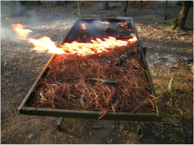
Fire behavior demonstration table in action, February 2018
When we left Guatemala City in the morning, the plan had been to spend the next day visiting sites in the Sierra de las Minas where INAB has been implementing some of what the U.S. Forest Service had been supporting, such as forest restoration and fire management. But Eliú informed us that “local events” had turned against our plan.
In just the last two days since our trip had been planned, members of some local communities in the watershed of the Río Pasabién were protesting something – just what wasn’t quite clear. Some policies of the government, perhaps. Maybe even of INAB, our institutional hosts. The story got murky, and we were not sure exactly what was going on. What was clear was that the roads leading to the sites we had been planning visit were blocked by local protesters, and not safe for us to travel under the auspices of INAB, and with their staff. We had seen smoke from a small fire on a ridge above the Río Pasabién as we passed Río Hondo on the way to Zacapa for our meeting. The rumor was that the fire was started by protesters, perhaps on land controlled by the hydroelectric company. Maybe by people from Santa Rosalia that I heard about on the last trip, who thought it unfair that the company profited from water coming from their watershed while they had no electricity.
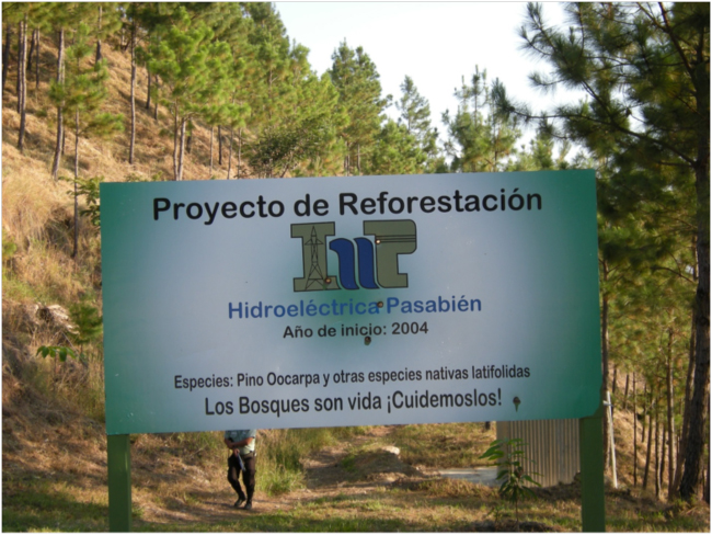
Sign for a forest restoration project of the Hidroeléctrica Pasabién, February 2016
Seeing what’s happening “on the ground” in ecosystems is what I love best, so I was disappointed, of course. But I also understand that what is happening in ecosystems around the world depends on people, and the local social context, so our need to abandon our previous plan was evidence that the socio-ecological system here at the southern slope of the Sierra de las Minas was not quite in a sustainable state.
So, after a night in a comfortable rural hotel in Río Hondo, we headed back to Guatemala City, taking a route through the departments of Zacapa, Chiquimula and Jalapa that avoided the construction that had frustrated us the day before. The rural roads were less congested and very scenic, giving views of the landscape here in this dry zone of southern Guatemala. We passed through the small old towns of San Luis Jilotepeque and San Pedro Pinula. The rough gravel road between them climbed up and over a pass, where in the small settlement of La Cumbra steep slopes had been cleared in the pine-oak forest to grow plantains. From the faces and clothing this looked to be predominantly indigenous Maya territory. People now live throughout this steep, dry, rough landscape, but it was probably even more densely populated in Mayan times.
As the road climbed up and down over ridges and through valleys, we experienced the elevational zonation of ecosystems that fascinates me – and which fascinated one of the first “ecologists,” Alexander von Humboldt, the German explorer and geographer of the late 18th and early 19th century, who described it in his classic study in 1805, Essay on the Geography of Plants. From leafless dry forests in the valleys, we passed through an oak zone and into pines on the ridges and passes and dropped down again through the same ecological transitions. Many little streams and rivers had a bit of water still, now a few months until the rains should start, but many were totally dry. In the now-leafless dry forest some trees were flowering, a very beautiful and striking effect. The most common was one with slick bark and big daffodil-yellow blooms on bare branches. A bit less common was a tree with apricot-pink flowers, and then another with purple flowers almost the color of jacaranda. And very occasionally one with sparse white flowers, as if a kleenex-wind had come through and left a few shreds of tissues in the trees.
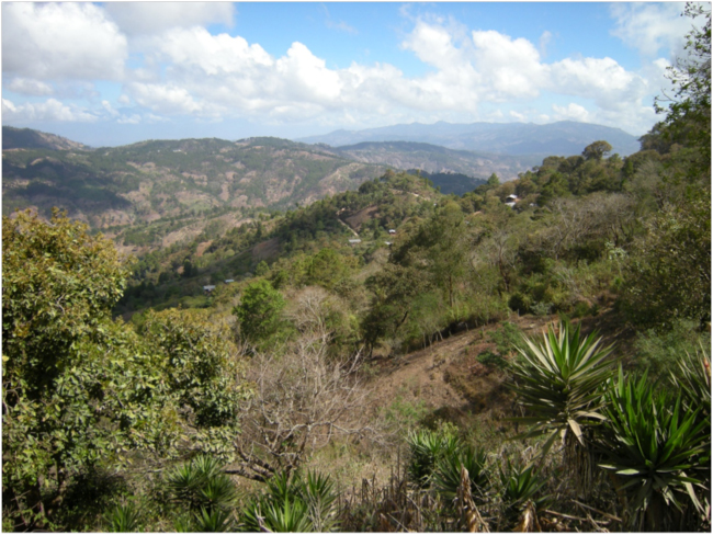
View of the landscape between San Luis Jilotepeque and San Pedro Pinula, Jalapa Department, February 2018
The USFS program in Guatemala has been providing expertise to Guatemalan government institutions on forest landscape restoration, and here we were seeing firsthand the kinds of challenges the country is dealing with: agriculture spreading up slopes that are too steep for annual crops without unsustainable soil erosion; streams and small rivers that are dry at the end of the dry season; poverty and lack of economic opportunities. INAB has programs that work with both large and small landholders to provide incentives and support for forest restoration and sustainable management. Along our backroads route back to Guatemala City we saw some evidence of that: a hand-lettered sign at one bend in a rough rural road marked an area supported by INAB’s program for small landholders, called by its acronym PINPEP. The sign said the area was for “Management of Natural Forest for Protection.” An area of 486 hectares has been protected since 2016, it stated, and “we are protecting the environment: no burning, no firewood cutting, no hunting.”
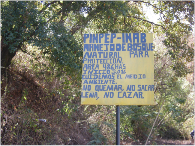
Sign announcing a PINPEP area on the road to Guatemala City, Jalapa Department, February 2018
We reached Guatemala City at the end of a sunny Friday afternoon, as the city was emptying and quieting at the end of another work week. Back in my highrise hotel with a view to the west, the perfect triangular cone of Volcán Agua was silhouetted against a hazy sky. Another day – another fascinating and unpredictable day – in my life as an international ecological consultant. I was exhausted, and exhilarated.
For related stories see:
Sources and related links:
- Instituto Nacional de Bosques, Guatemala
- Pollo Campero
- Guatemala Tropical Forest and Biodiversity Assessment. March 2016.


May 4, 2018 11:49 am
Hi Bruce. Around 1990 when I was with IUCN I worked with Defensores de la Naturaleza to help support their efforts to acquire private land and easements in the Sierra de las Minas in order to protect watersheds and biodiversity. As I recall, that range was a bit of a water tower for the region. Defensores had developed one the earliest formal payment for ecosystem services scheme that I can remember, which was a partnership with a local bottling plant to acquire land to secure their supply of clean water. I wonder how that fared over time? It sounds like the there has been some progress, which would be encouraging, given that in this business we are always swimming against the current. Thanks for sharing!
May 8, 2018 2:10 pm
Thanks for the comments, John! The water fund in the Sierra de las Minas organized by Defensores de la Naturaleza is still sputtering along, as far as I know. One of the purposes of my site visit there in 2016 was to learn more about the water fund, and in my blog at the time, “Sugar Maples, Climate Change, and Ecohydrology in the Sierra de las Minas of Guatemala,” I wrote the following summary: “A Coca Cola bottling plant in Río Hondo, a bottled drinking water company, Agua Pura Salvavidas, Ambev, another beverage company, and ENEL, a hydroelectric company in San Geronimo are contributors to the Fondo de Agua. The water fund aims to use money collected from these water users to protect water recharge areas in upstream watersheds and improve forest management there. So far the amounts contributed are small – around $25,000 U.S. dollars each – and the areas targeted are modest – only hundreds of hectares out of hundreds of thousands in the Biosphere Reserve. The need for scaling up is clear. Hidroeléctrica Pasabién, the hydroelectric company whose system we’d seen, has so far refused to join the water fund. Guatemalan water law doesn’t provide any real incentives for them to do so.” The hydroelectric company mentioned – which wasn’t participating in the water fund at that time, and probably still is not – seemed to have something to do with the local unrest that blocked our trip to the field this year. Progress on these “payments for ecosystem services” schemes seems often to be challenging and slow, although there are some success stories in the U.S. and around the world, of course.
May 4, 2018 11:51 am
And I forgot to mention, back then one of the rangers was murdered by ranchers, if I remember correctly. Evidently the range is heavily grazed.