
The Rufiji River is Tanzania’s largest in terms of flow. Its catchment in the southern highlands stretches from Mbeya in the southwest, to its mouth at the Rufiji Delta, inshore from Mafia Island on the Indian Ocean. The Ruaha River, especially its main branch, the Great Ruaha, provides about one-fifth of the water in the Rufiji River Basin. We set out from Dar es Salaam – the “Place of Peace” in the Arabic of its founders — on a bright Saturday morning in early June to see the Great Ruaha as it crosses through Ruaha National Park, and learn about the complex challenge of managing the precious flow of water in this river.
After fighting our way out of the sprawling city on overwhelmed roads clogged with cars, “dala-dala” minibuses overstuffed with passengers, and cross-country trucks belching thick black diesel soot, we were finally on the open road, the A7, heading for Morogoro. Morogoro is an agricultural hub, home of Sokoine University of Agriculture. One of our team members for the Environmental Threats and Opportunities Assessment we were conducting for the U.S. Agency for International Development, Pantaleo Munishi, is a professor there. We ate lunch in Morogoro, and headed on into the afternoon, the A7 passing through Mikumi National Park, where a few zebra wandered in dry woodland along the road, the grasses already dried to brown. It was about a month into the “winter” dry season here in south-central Tanzania, which will last until the rains start again sometime between October and December.
We passed through the town of Mikumi, and turned west up the gorge of the Ruaha. Baobabs became a common component of the forest here. They had shed their leaves for the dry season, so their iconic shape showed clearly. Some people have called baobabs the “upside down tree” because without leaves their stubby, twisted branches at the top of a bulging trunk look like roots reaching skyward. Across the river, mountains rose steeply, covered in silvery, now leafless woodland with scattered baobabs. These mountains are the northwestern, rain-shadowed side of the Udzungwa Mountains National Park. We would travel to the southeastern, windward side in a few days, where the warm, moist winds from the Indian Ocean rise against the mountains and create a lush evergreen forest. After leaving the gorge, we crossed the now-dry Little Ruaha River at Mbuyuni, and the road climbed to Iringa, on a breezy ridge of granite outcrops above the valley of the Little Ruaha. Iringa was built as a fort and headquarters for German battles to subdue the local Hehe people and take over this good highland agricultural land at the beginning of colonial era.

Baobabs at Mbuyuni, Udzungwa Mountains silhouetted on left
The sun was setting as we left Iringa, heading west for the entrance to Ruaha National Park, on a gravel road that soon became very rough, potholed, and washboarded, so that our speed dropped to around 30 or 40 kilometers an hour. When we left Dar this morning at 8:30, my Tanzanian team members estimated a travel time of seven hours. By that reckoning we should have been to our destination an hour ago, at least, and now sipping sundowners. But upon further questioning it turned out that neither of them had actually been to Ruaha National Park, as I had assumed all along. We had no map – I had also assumed that the Professor would have one – and so had no real idea of how far we had yet to travel. Darkness fell, and after an hour we spotted a few houses by the road with dim kerosene lanterns for light. Zakiya Aloyce, the other Tanzanian member of our team, hailed a man out of the darkness, and asked how far to Ruaha. “Oh, very far!” was his enthusiastic answer. Of course there were no signs giving either distance or direction. We went on, feeling our way through several forks in the road, guessing the route by which one seemed more travelled. Finally we came to Tungamalenga village, and finally then knew we were only about five kilometers from the Tandala Tented Camp, where we had a reservation to stay. We rolled in at 9:30 PM, after travelling thirteen hours, and were greeted by the owners, John and Dionysia, and their Maasai askaris, with big “torches” – flashlights, that is, in the British English of East Africa. They took us to our platform tents to quickly drop our dusty bags, and then we ate a good dinner washed down with plenty of cold beer in their big, open-air dining room with a palm-thatch roof. The plan was to head out early on a morning drive into the national park to get oriented to the Great Ruaha Ecosystem.
It was a beautiful night, ringing with bell crickets, and the moon rose at about 11 PM, lighting a small waterhole in the streambed just below my tent. Lions were roaring in the night, and I was awakened at 2:30 AM by the sound of an elephant wandering by and ripping off mouthfuls of grass and bushes in the moonlight, stomach rumbling like distant thunder.

Breakfast under the baobabs, Tandala Tented Camp

Platform tent, Tandala Tented Camp
Ruaha National Park covers a large swath of classic East African “bush” country – a mosaic of savanna woodlands of various types, from that dominated by acacias and bushes of the genus Commiphora, to true miombo woodland, dominated by trees in the genus Brachystegia. The road from the entrance gate crossed this dry season bush, skirting below a big hulking mountain, and dropped down to cross a bridge across the Great Ruaha before climbing up to the park headquarters. There was still a good flow in the river, but not really a large amount of water, and it was early in the dry season. The river is the lifeblood of the park, providing a ribbon of water that draws in and concentrates animals from the huge surrounding landscape over which they disperse and feed during the rainy season.

Mock charge by elephants along the road to the Ruaha National Park Headquarters

Great Ruaha River in Ruaha National Park
When we met with the Head Park Warden, the manager of the park, Stefano Qolli, and his senior staff on Monday, we learned that the main threat to the Great Ruaha Ecosystem and its wildlife is the drying up of the Great Ruaha River. In 1993, the Great Ruaha dried up completely during the dry season for the first time on record. Why? Kapunga Farm, a large 3,000 hectare private rice farm in the Usangu Wetlands, upstream from the Ruaha National Park, was established with a loan from the African Development Bank from 1988 to 1992. According to the “project completion report” for this loan, “At the time of appraisal, environmental impacts were not taken into consideration.” But when the Bank did finally complete the Environmental Impact Assessment, it found that the project would create “significant” hydrological changes on the Ruaha River. The EIA stated that “As a result of the irrigation works, a very significant proportion of the waterflow of the Great Ruaha and Chimala rivers is diverted for irrigation purposes.” Whoops! Too late. The project had already been built.
A 2008 Research Brief published by the USAID-funded Global Livestock Collaborative Research Support Program, titled “The Unintended Consequences of Development Assistance: The Case of Usangu in Tanzania,”concluded that: “Three smallholder rice irrigation schemes were established with development assistance in Tanzania in the 1980s and early 90s aimed at improving agricultural livelihoods in the region. The projects did not accomplish their stated goals, but more problematically, they precipitated a cascade of unintended consequences. The primary effect was that legal channelization of water catalyzed illegal diversions and satellite farms surrounding the rice schemes. The resultant loss of water was (and remains) the central driver in a cascade of unintended environmental and socioeconomic effects including: a 77% reduction in the area of the Ihefu [Usangu] swamp, the important wetland habitat of the Great Ruaha River; over 60% loss of dry season habitat in Ruaha National Park;… and the loss of electricity produced by the Mtera Hydroelectric Plant. The social and economic costs of these unintended consequences remain untallied, but the power crisis alone likely cost the Tanzanian economy approximately one billion U.S. dollars. This case highlights the need for development assistance to control the genesis and propagation of unintended consequences which could vastly outweigh the benefits of the assistance program.”
Ruaha National Park’s Head Warden, Mr. Qolli, told us “Every year now, the river dries from September until December – and sometimes even until March. To save the park and its wildlife, we first need to determine the environmental flow requirements, and then apportion the amount of water so that those ecological flows are maintained,” Mr. Qolli said. “What we really need is integrated river basin management on the Great Ruaha.”
In an attempt to rectify this environmental disaster, in 2008 the Usangu Wetlands were annexed as part of the national park. Disputes continue between the Ministry of Natural Resources and Tourism, the parent ministry of the Tanzania National Parks, and the Ministry of Local Government over some settled areas that were annexed, where people may be forced to move out. But the problem now is that the major rivers upstream from the Usangu Wetlands are still being diverted for rice farming, and water for ecological needs is not returned to the wetlands, and thereby to the Great Ruaha River, in sufficient quantities.
“We have to have rice,” said Mr. Qolli. “But the policy of Kilimo Kwanza, Agriculture First, that is being pushed by the Ministry of Agriculture emphasizes irrigated rice farming. This policy is not coordinated with the policy for conservation of wildlife. We need to harmonize these.”
The Ministry of Natural Resources and Tourism has its own policy, which emphasizes developing the wildlife tourism potential of the “Southern Circuit” of parks in Tanzania. The “Northern Circuit,” including Tarangire, Lake Manyara, and Serengeti National Parks, and the Ngorongoro Conservation Area, are currently the tourism “gold mine” for the country. Tour operators often link this northern circuit with wildlife areas in southern Kenya, Amboseli and the Masai Mara. In contrast, the southern parks of Tanzania – Mizumi, Udzungwa Mountains, Ruaha, and the Selous Game Reserve – are much less visited, and much less accessible – as we discovered in our long, slow drive from Iringa to the main gate of Ruaha – and with much less infrastructure for tourism. The wildlife and scenery of the Southern Circuit are spectacular, and the potential is there for further development. But this potential seems pitted against the ideology of “Kilimo Kwanza,” with its emphasis on irrigated rice agriculture above everything else. This ideology was summed up perfectly by the head of the Rufiji Basin Development Authority, an unapologetic promoter of irrigation and hydropower development, whom we met in Dar the previous week: “We can’t jeopardize our development for conservation!” he said enthusiastically.

Afternoon giraffe, Ruaha National Park
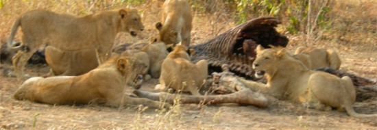
On our Sunday drive through the early dry season bush of Ruaha, we encountered elephants, giraffe, buffalo, impala, and two prides of lions. The first pride of ten lions, sleeping in the shade of a baobab, were so full after a feast the previous night that they completely ignored us as we parked in our Land Cruiser a few meters away and watched them for half an hour. The second pride of thirteen was so busy eating a giraffe they had killed three days earlier that they too ignored us completely while we watched them gorging on the putrifying flesh, almost gagging when the wind shifted slightly to bring the smell our way.

Lions feasting on giraffe

Elephant skull, Tandala Tented Camp

Ancient baobab above the Great Ruaha River, Ruaha National Park
Donors, including USAID, are now being asked by the Tanzania Ministry of Agriculture to support “Kilimo Kwanza” – which basically means to support another round of expansion of irrigated rice farming like that of the late 1980s that dried up the Usangu Wetlands and the Great Ruaha River. “Agriculture First,” and everything else second – nature, biodiversity, conservation, tourism development, and sustainability. This time, let us hope that adequate Environmental Impact Assessments are completed before the projects are funded and developed, unlike in the case of the Kapunga Rice Farm and others in the Usangu Wetlands. The Great Ruaha Ecosystem seemed too precious, to us, to be sacrificed for more private rice farms and private profits, at the expense of conserving and realizing the long-term economic benefits from its spectacular biological diversity.
Related Links:
- Tandala Tented Camp
- Project Completion Report, Kapunga Rice Irrigation Project Tanzania. African Development Bank.
- The Unintended Consequences of Development Assistance: The Case of Usangu in Tanzania.Research Brief 08-02-HALI. Global Livestock CRSP. Nov. 2008
- Click here to see more photos from this trip


July 22, 2012 5:45 pm
Once again, enjoyed the text and pictures. Here’s my comment:
Equatorial Africa, including Tanzania, is no closer to feeding itself than it was 40 years ago. So why is “kilimo kwanza”? (it was “first” 40 years ago, as well). As you seem to suggest, the answer probably has more to do with the existence of state and international bureaucracies, rather than any solution to under-development. Countries that truly feed themselves have some unsurprising commonalities: their population is overwhelmingly urban; human fertility is at or below replacement (just above 2 children per woman); and they typically maintain remarkably low densities of population in their agriculture areas and relatively large land holdings per farm.
Tanzania is a long way from being able to employ its high-fertility population (still around 5.5 children per woman) with urban manufacturing and service industries. Nonetheless, the future is all too obvious: small, healthier, well-educated families; a larger proportion of people in urban areas; fewer people in rural areas; larger, more efficient farms; capital investments in both small and large urban areas. Perhaps, in such a future, Africa’s remaining natural ecosystems will have a place. But even then, the sustainability of the special places like Ruaha would be in doubt.
August 24, 2012 11:57 pm
[…] Wetlands, supported by international donors in the late 1980s and early 1990s, which dried up the Great Ruaha River, and so we wanted to see the situation here in the Kilombero Wetlands for ourselves. We turned off […]
October 17, 2012 3:54 am
Bruce,
Please contact me. I’m a Wetland Conservation Biologist and plan to do a presentation inspired around your article. I have been to TZ recently, 2011 and 2012, as well as in 1991. I’d like your first hand account of what’s going on there. Thank you.
Michael Barr, AB NAWMP Coordinator: abnawmp.ca
October 21, 2012 8:01 pm
Great read on Ruaha! Please visit our website ruahanationalpark.weebly.com ..Ruaha is ‘Tanzania’s Best Kept Secret’ and the largest park in East Africa. The site has everything you need to know about Ruaha. Any contributions or articles would be greatly appreciated
April 20, 2020 7:10 am
AS I understand it…. what you discovered on your safari was that it was not the Rice scheme per se that used up large amounts of water, but illegal connections by villagers who settled around the rice scheme, and who somehow use the diverted or canalized water for their own shambas. Another crucial fact is that 70 percent of water evaporates by evapotranspiration and the whole eco system has suffered, as well as the economy. One can go on trying to blame and find fault but the fact is the damage has been done , but the question is now how do we fix the damage, so that the river flows all year, or at least 10 months of the year. What is the latest situation. I am an ecologist who worked in Tanzania for 13 years , so I have followed this fiasco for many years.