
December 2016. Deltas are dynamic and fascinating places, geologically and ecologically, as I was reminded during a December visit to New Orleans and points west and south: the vast delta of the Mississippi, where rain and rivers from all of the watersheds between the Appalachians and the Rockies – 41% of the continental United States – meet the Gulf of Mexico.
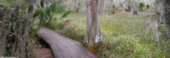
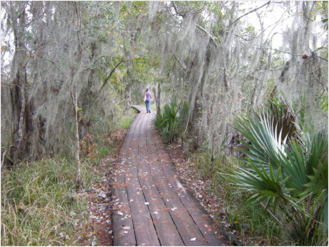
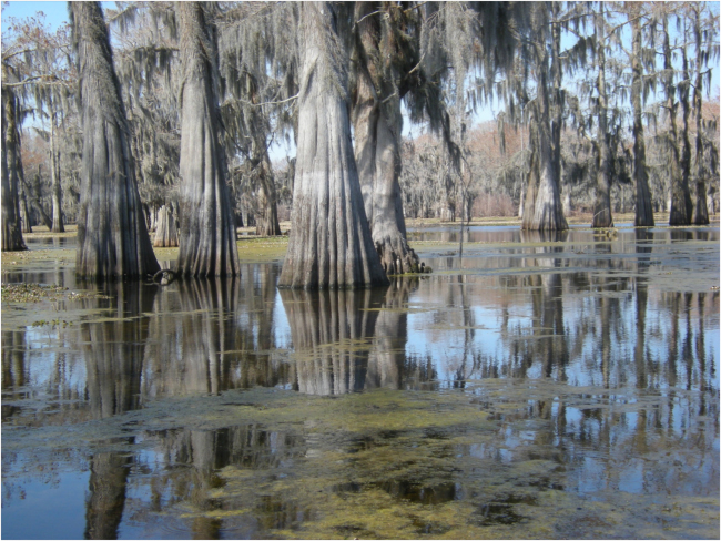
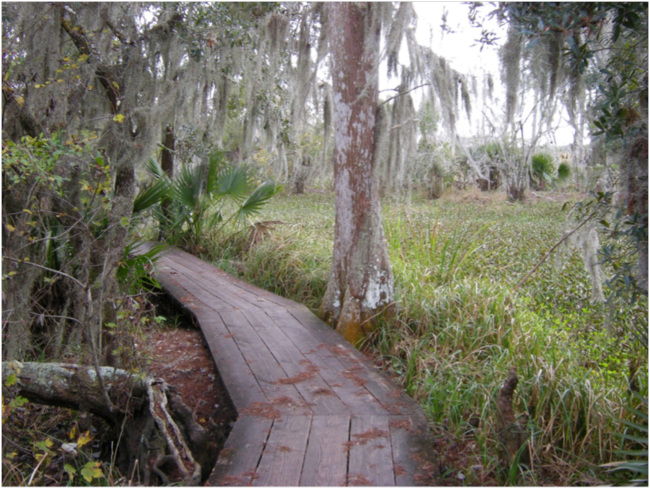
After breakfasting on beignets and omelettes and overdosing on New Orleans style chicory-laced coffee, we drove a half-hour south of the French Quarter to the Barataria Preserve, one of the scattered units of the Jean Laffite National Historical Park and Preserve. The Bayou Coquille Trail starts on high ground where giant live oaks spread their Spanish-moss-draped branches – probably the ridge of an ancient natural levee of the big river from an earlier episode of delta shifting – and drops almost imperceptibly down to where the water table reaches the surface and the vegetation changes to palmetto and then baldcypress swamp. When the trail reached an old canal dredged through the swamp for cutting and transporting the baldcypress during an earlier era it went up on a boardwalk, and out to an overlook across a floating marsh.
Boardwalk on the Bayou Coquille Trail, Barataria Preserve
Floating marsh, Barataria Preserve
Two-thirds of the Barataria Preserve is floating estuarine marsh. Here in Louisiana this habitat is known by the French terms flotant or tremblant. Floating marsh is a layer of peat soil formed by centuries of decaying marsh plants held together by the roots of the living plants at the surface. Under this floating layer, water has filled the space where the unconsolidated mineral soils below have subsided. In some places these floating mats can even support trees that colonize them. But human and animal travelers crossing these floating marshes are on shaky ground – maybe analogous to walking on a frozen lake with patches of thin ice. High water from hurricanes or abnormal rainfall can break up the flotant, causing it to drift and reform elsewhere.
——-
As rivers transport sediment and drop it in the slack water along their banks, they build their own natural levees that grow taller and taller, containing the flow in the channel. But when the bottom of the channel is raised higher than the surrounding land, the river is in an unstable situation, and if a flood causes the natural levee to be breached it will cut a new course, taking the steepest, shortest route downhill. That geology and physics explains why deltas are shifting, unstable landforms.
Ecological communities move and adapt to this shifting ground. Vegetation follows the old natural levees, ridges, swales, and channels, responding to the water level and degree of flooding. In mountains, a few thousand feet of elevation change might be needed to shift one forest ecosystem to another type. In the Mississippi Delta an average change in water level of one foot can change a forest from live oaks to maple and palmetto swamp, or from baldcypress swamp to open marsh. Where freshwater and saltwater meet and mix, the ecological community also responds to the degree of salinity. The cutting of canals for baldcypress logging, and later for oil and gas production, allowed salty water to penetrate farther into the delta, sometimes killing vegetation that isn’t salt tolerant, like baldcypress. Hurricanes and storm surges that punch through protective barrier islands and estuarine marsh also push salty water farther than normal into the delta. The wetlands in the delta have been called “speed bumps for hurricanes;” some studies have shown that three miles of marsh can reduce storm surge height by a foot. Human-caused climate change is raising sea level and increasing the intensity and frequency of hurricanes, amplifying this old dynamic.
Mixing geological jargon almost poetically into a relatively simple sentence, Wikipedia describes this geo-ecological dynamic: “Because of the natural progradation and degradation periods, the building of the Mississippi River Delta is an integrated and long-term process that has given the region its unique mix of ecosystems, habitats and landforms.” The excellent visitor center at the Barataria Preserve had exhibits that illustrated this process and its ecological consequences.
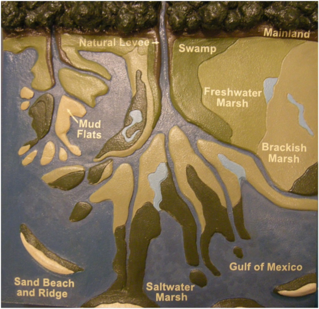
Exhibit depicting the interplay of delta geomorphology and ecological communities, Barataria Preserve Visitor Center
The modern day Mississippi River Delta plain began to develop geomorphologically around 7,000 years ago, as sea level rise slowed when most of the continental ice sheets of the last ice age had melted. The river shifted its course in the delta about every 1,000 to 1,500 years, creating six lobes that now define the southern Louisiana landscape. Three of the six historical lobes of the delta are named for the “parishes” that now occupy them: St. Bernard, Lafourche, and Plaquemine.
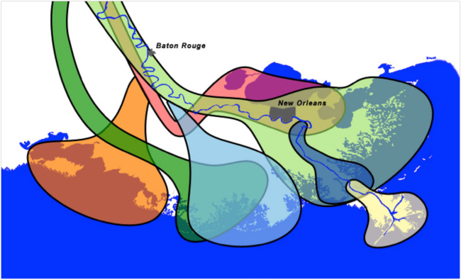
Historical geology of the Mississippi Delta, showing major lobes: Salé-Cypremort (~ 5,000 years ago) is orange; St. Bernard (2,800-1,000 years ago) is light green; Lafourche (1,000-300 years ago) is light blue; Plaquemine (750-500 years ago) is dark blue
One day – after more beignets and coffee, of course – we drove south on Louisiana Highway 308, down the riverlike Bayou Laforche to Port Fourchon and Grande Isle in Lafourche Parish. The road followed the old Lafourche lobe of the delta, where from a thousand until around three hundred years ago the Mississippi discharged its muddy load. The tricky river then shifted back eastward onto the earlier St. Bernard lobe, punched a new outlet, and built the low land of Plaquemines Parish, through which it now exits the continent.
Starting in the 1930s, the discovery of huge deposits of oil and gas transformed the economy, ecology, and culture of the Mississippi Delta. Roads and canals were built to provide access to wells, and pipelines carried away the gas and oil. Deltas are always sinking, as new, unconsolidated sediment compacts, but sucking out the fossil fuel foundation of the Mississippi Delta only hastened that process. Today around 30% of all the oil and gas consumed in the U.S. passes through these sinking wetlands.
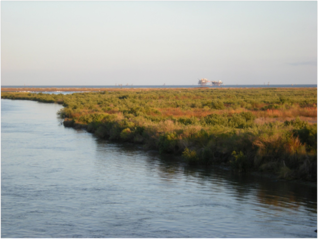
View offshore from Port Fourchon
Looking offshore from Port Fourchon a forest of oil platforms spread to the horizon. Somewhere out there, far out of sight, was the “Deepwater Horizon,” infamous for causing the largest oil spill in U.S. waters so far. Port Fourchon services all of this offshore oil and gas production. From a bridge across a channel on the edge of town we were surprised to hear a lone dolphin puffing and blowing as it swam slowly toward the hissing industrial port. I guessed it was a “blue” dolphin – although its color was silvery grey.
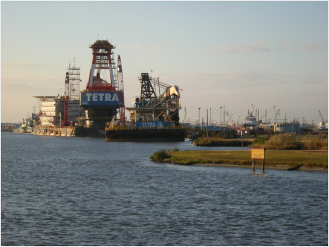
Looking up the channel toward Port Fourchon
——-
The Atchafalaya River is currently the largest “distributary” of the Mississippi River, as hydrologists call an alternative outflow route that carries a lot of water during floods. Note the parallel of “tributary” and “distributary”: tributaries merge up the watershed to carry water into a river, and distributaries fan out at the delta to help distribute water out of the river into the ocean. As the main distributary of the Mississippi, the Atchafalaya dumps a good bit of eroded Midwestern farmland into the Gulf. It’s plume of sediment shows up clearly in photos from space.
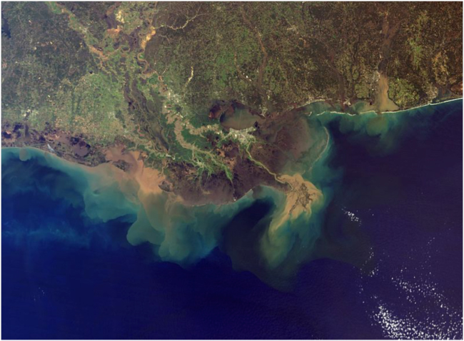
Satellite image of the Mississippi Delta; the brown sediment plume from the Mississippi River is at right, and from the Atchafalaya River to the left (west)
The oldest of the six delta lobes, called by geologists the Salé-Cypremort, was the main outflow of the Mississippi around 5,000 years ago, centered on Terrebonne, St. Mary, and Iberia Parishes – the Atchafalaya Basin. And it seems to be trying to take over the flow of the river again, trying to assert its ancestral geomorphological right as the shortest, steepest route to the Gulf. The U.S. Army Corps of Engineers is engaged in battle with the river as we speak; the Morganza Spillway, a giant dam-like structure, is the fort from which the battle is being waged. Geological forces are waiting for just the right moment to attack Morganza, capture the Mississippi main channel again, and make New Orleans a backwater port. Someday the river will win, of course – but until now all’s quiet on the western front, as we saw on a day trip to paddle among the Atchafalaya baldcypresses.
We drove west on Interstate 10, passing Baton Rouge – yep, more coffee and beignets to start the day! – and into the Atchafalaya Basin. From McGee’s Landing near Henderson we rented a canoe and paddled into the surreal, cathedral-like swamp forest of old baldcypress draped in the wispy bromeliad called Spanish moss (Tillandsia usneoides).
Baldcypress swamp, Atchafalaya Basin
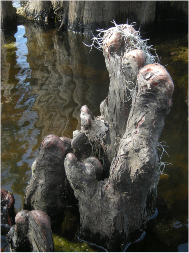
Baldcypress “knee” with Spanish moss, Atchafalaya Basin
The Atchafalya swamps would have been prime habitat for the now-extinct Ivory-billed Woodpecker, probably first painted by John James Audubon when he was not far from here at the Oakley Plantation in the summer of 1821.

Ivory-billed Woodpecker (Campephilus principalis). John James Audubon. Plate 66 (detail), Birds of America.
——-
Audubon was in London in the winter of 1827-28, continuing to produce and promote the Birds of America. It was going relatively well. His masterwork was receiving more interest and acclaim in Europe than in the United States. But he had been away from his wife, Lucy, and his two sons for a year and a half, and the hard work and loneliness were weighing on him. Just before Christmas of 1927 he wrote a note to an English friend, saying he “had the blues completely.” Use of the term “blues” to refer to melancholy feelings probably originated from a one-act play called Blue Devils by George Colman in 1798, according to Wikipedia. Coleman, a British writer living in London when Audubon was there, published a collection of his writing in 1827. That may well have been the source of Audubon’s use of the term “blues” to describe his state of mind.
For us now, of course, the word “blues” is mainly associated with a genre of jazz and the feelings conveyed by its music and lyrics. If you look up the word, you will find something like “melancholic music of black American folk origin,” or “feelings of melancholy, sadness, or depression.” The origin of the music that carried those emotions was the music that slaves, mostly from West Africa, brought with them and adapted in their new circumstances. Think how you’d feel, captured, sold into slavery, and shipped to another continent. Talk about shifting ground beneath your feet! Talk about feelings of sadness or depression!
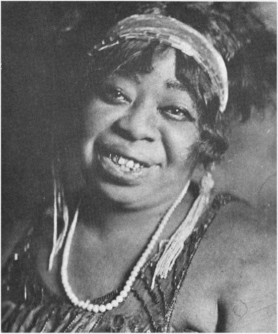
Ma Rainey, “Mother of the Blues”
Blues music is characterized by call and response patterns, and notes from African music that don’t quite fit into the conventional western scale. Those microtonal notes are often called “blue notes.” The lyrics of blues songs are often down-and-out, sad, melancholy, depressed. Ma Rainey (1886–1939) was known as the “Mother of the Blues.” The Royal Street Winding Boys, a group we heard at a little French Quarter bar called 21st Amendment, featured many of her songs.
Blind Lemon Jefferson, one of the most popular blues singers of the 1920s and ‘30s, wrote a song about the great Mississippi flood of 1927 called “Rising High Water Blues.” This was the most destructive flood in the history of the United States. Twenty-seven-thousand square miles of land were flooded up to a depth of 30 feet, and almost a quarter-million African Americans in the Delta were displaced, leading many to migrate to northern cities. Some of the lyrics:
Backwater rising, Southern peoples can’t make no time
I said, backwater rising, Southern peoples can’t make no time
And I can’t get no hearing from that Memphis girl of mine!
But the blues were and are also a music of resistance and resilience, of “we shall overcome.” Survivor music, make the best of it music, you only have one life to live music. The blues is melancholy but triumphant. In an essay posted in May 2014, “Belizean Blues,” I wrote that the emotion described as the blues is “a kind of longing, a kind of sadness, but with a strong and yet still tender heart.”
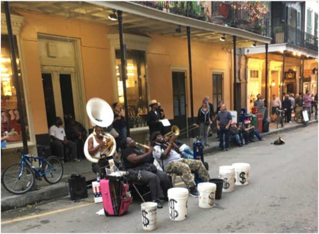
Doreen’s Jazz Band playing on Royal Street, French Quarter, December 2016
——-
In her opinion piece in the Washington Post on Saturday, February 11th, Alexandra Petri (who is fast becoming one of my favorite opinion writers at the Post) showed her familiarity with the short story “A Sound of Thunder” by Ray Bradbury, a popular science fiction writer of the early 1950s, and she picked up on a theme I wrote about in January 2016 in a blog titled “Butterflies in a Blizzard.” The headline of her op-ed was “The Trump administration came here from an alternative universe. It’s a fact.” She wrote: “It is not their fault that their facts appear to be quite different from what is happening in the universe where most people live. They did not ask to come here. Something went wrong with the timeline, is all. Somebody stepped on a butterfly, and here we are.”
Stay on the path! Barataria Preserve
If you read “A Sound of Thunder” you will see how Bradbury posited that the killing of a single butterfly can alter evolution and history, and even influence an election. Who stepped off The Path to bring us here, to the Trump era? When the Time Safari guides finally figure out who it is that has that dead butterfly in the mud of his boots, there will be a reckoning, you can be sure.
We all woke up one morning last November and found that we’d been captured, and taken to a country we don’t recognize, far from home. No wonder so many of us are dispirited, depressed, distraught. Blue! What we thought was solid ground has suddenly become flotant: floating, trembling marsh. But – in a geological and ecological metaphor – we can be completely confident that the old river’s gonna cut a new channel, and the resilient communities waiting for that shift will colonize and retake the new landscape.
And what can we do in the meantime? Stay on the path! We’ll find dry and solid ground again, brothers and sisters! And until we do we’ll all go along singing the delta blues to keep our spirits from sinking as we walk over this shifting ground beneath our feet.
For related stories see:
- The Astonishing World Under the Sky: Wandering with John James Audubon in Louisiana Woods. December 2016.
- Butterflies in a Blizzard, or Chaos in Colorado and What It Means for Us. January 2016.
- Belizean Blues. May 2014.
Sources and related links:
- Barataria Preserve, Louisiana
- Mississippi River Delta
- Atchafalaya Basin
- Ivory-billed Woodpecker. John James Audubon. Birds of America. Plate 66.
- Under a Wild Sky: John James Audubon and the Making of The Birds of America, by William Souder, 2004. Milkweed Editions.
- Royal Street Winding Boys: “If It Don’t Fit, Don’t Force It”
- Doreen’s Jazz Band, New Orleans
- Rising High Water Blues by Blind Lemon Jefferson.
- Alexandra Petri, 11 Feb. 2017, The Trump administration came here from an alternative universe. It’s a fact.
- A Sound of Thunder. Ray Bradbury. 1952.


March 4, 2017 6:19 pm
Powerful stuff. Thanks for sharing!
dave
March 6, 2017 4:13 pm
Thanks Dave, glad you enjoyed it!
March 6, 2017 10:47 am
Great blog…love the weaving in of the history of the blues! The illustration above of the historical lobes of the delta could be looked at as a horn section of blues and jazz instruments…trombone, tenor sax, clarinet, tuba…
I need to find some recordings of Blind Lemon Jefferson. I wonder if he was the inspiration of my favorite bar in Cincinnati, the Blind Lemon, located in the Mt. Adams section.
Lastly, I love the ambition and optimism of Doreen’s Jazz Band, which set out, not one, not two, not three, not four, not five, but SIX buckets for which admiring passersby could show their appreciation!
March 8, 2017 7:47 pm
Kevin,
I really appreciate your sharp eye, which makes the “everything is connected” connection in a way I didn’t notice in that image of the historical lobes of the delta: the Old Delta Blues Band has been blaring its continent-eroding, muddy-waters blues into the Gulf since the last ice age!
And yes, SIX buckets!
Thanks, Bruce